

Ca' d'Alfieri "Coast to Coast"
A circular hike that starts and ends at Ca' d'Alfieri, offering simultaneous views from the summit of Pizzo d'Oca across Val Noveglia, Val Ceno, and the thousand-year-old Bardi fortress.
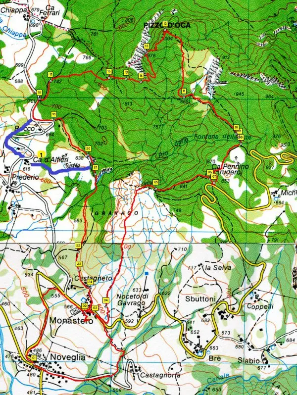
A lovely circular route starting from Agritourism Ca' d'Alfieri that crosses La Via degli Abati, the Apennine Bridle Trail and several CAI paths multiple times before returning directly to Ca' d'Alfieri. Ancient tracks that once connected small communities in the valley, now cleared and reopened for a beautiful hike through centuries-old chestnut woods, oak forests, stone structures, paved paths and dry-stone walls. The trail climbs to 1,000 metres to reach the sandstone ledge of Pizzo d'Oca, with a spectacular 360° view over Val Noveglia, Val Ceno and Bardi Castle.

The route begins at Agritourism Ca' d'Alfieri. Passing in front of La Casella, a short uphill path cuts across a couple of bends on the tarmac road and emerges onto La Via degli Abati. Continue climbing a little further to where the asphalt ends.
Take the wide path on the right that enters the woodland (no. 18 on the map) and ascend through old chestnut trees. When the path forks, keep right, continuing uphill (no. 17 on the map), until you reach the clearing of the Shelter with Picnic Table (no. 16 on the map) — a perfect spot for a short rest in the green.
Continue along the track to a large fork, then take the path that climbs towards Pizzo d'Oca (no. 14 on the map). Those who prefer not to climb to the summit can cut across via CAI trail 803 — easy and shaded — passing an enormous centuries-old chestnut tree. This path then rejoins the descent from Pizzo d'Oca (no. 11 on the map).
The path narrows and climbs through vegetation and large sandstone boulders. It passes the remains of an ancient quarry where the stone of Pizzo d'Oca was once extracted, then reaches a truly spectacular viewpoint. A tongue of sandstone juts out into the void, offering a breathtaking view of the valley (no. 13 on the map) — a kind of miniature "Preikestolen", the cliff overhanging the Norwegian fjords, right here in the Parma Apennines!
Continue climbing to the top of Pizzo d'Oca, 1,004 m (no. 12 on the map), with a wide view stretching over Val Ceno. The path becomes narrower and less defined among tufts of grass and shrubs, but with a little care it is easy to follow; descend until you once again meet CAI trail 803 (no. 11 on the map).
The path continues through woodland alongside ancient dry-stone walls and stretches of paved track. Cross the Rio Fontana della Lite (no. 9 on the map) and reach the ruins of Ca' Pennino (no. 6 on the map).
Continue under cover of vegetation before emerging into the open among badlands and juniper bushes (no. 5 on the map).
The scenery and underfoot conditions change completely. The landscape becomes "lunar" among sandstone and badlands. The view over Val Noveglia is total, dotted with small clusters of houses emerging from the vegetation.
Descend through loose and slippery rocky sediments — proceed slowly and carefully — to the Three Crosses (no. 4 on the map). Another short, demanding descent follows (Via degli Abati waymarking begins here) and you arrive at the village of Monastero (no. 3 on the map), heralded by its imposing bell tower. The baroque church was built on the site of an ancient Benedictine monastery. A beautiful fountain with benches is just what you need after the descent.
After a restorative rest, set off through the small village with its beautiful stone houses — sadly many now uninhabited and in poor condition. The clearly marked, flat path continues until it crosses the Rio Fontana della Lite again; cross a small wooden bridge and shortly after take the left-hand fork that leads directly to Ca' d'Alfieri (no. 21 on the map).
Cross a dirt track and a small badland gully, then enter the woodland guided by tall dry-stone walls (this was the old village road!), passing a stone water trough and a stone washhouse.
A few hundred metres more and you arrive at the ancient farmhouse of Ca' d'Alfieri, built around 1860 using local stone and inhabited by the "alfieri" — as the most important people of the area were called. Now is the time to savour dishes prepared with ingredients grown on the organic farm, or to rest in the beautifully restored rooms furnished with period pieces.

Sources:
valcenotrek.it by Giorgio Tanzi – IT89 Val Noveglia: to Pizzo d'Oca from Monastero
Via degli Abati Hiking Map – Historical and environmental route
Val Ceno Hiking Map – From Monte Penna to Monte Barigazzo
Route survey: Maurizio Bovi, Tiziana Azzolini, Davide Galli